Closures/en: verschil tussen versies
Nieuwe pagina aangemaakt met '===Closure requests=== Requests for closures are welcome in the [https://wazebenelux.slack.com/archives/C04CBAYGB Slack closure channel]. Wazers who want to report closures and do not have a Slack account can do so via the forum: [http://bit.ly/NLforum_closures Dutch forum closures].<br /> <br> Example closure request <br> <br>Specify your closure request as follows: * Level * City and optional...' |
Nieuwe pagina aangemaakt met '===Enter Closings=== right|300px|Input closure Select the segments for which you want to enter the closure and click on the Closure tab.<br> Now click on the <b>Add a new closure</b> button.<br> Then enter the following information: * <i>Description</i>: If possible, provide a description of the work and the source. For example, "Asphalting work - Melvin 257413", "Work - Municipal site" or "Closure - own observation". If the De...' |
||
| Regel 43: | Regel 43: | ||
* Source of the closure information | * Source of the closure information | ||
===Enter Closings=== | |||
[[File:NL-closure-invoeren.png|right|300px|Input closure]] | |||
[[File:NL-closure-invoeren.png|right|300px| | Select the segments for which you want to enter the closure and click on the Closure tab.<br> | ||
Now click on the <b>Add a new closure</b> button.<br> | |||
Then enter the following information: | |||
* <i>Description</i>: If possible, provide a description of the work and the source. For example, "Asphalting work - Melvin 257413", "Work - Municipal site" or "Closure - own observation". If the Description field does not have enough space, add a [[Map Comment]]. | |||
* <i> | * <i>Direction</i>: A→B, B→A, 2 dir.⇆ | ||
* <i> | * <i>Start and End</i> date and time of the closure. | ||
* <i> | * <i>Event</i>: None or one of the available [[Major Traffic Events]]. | ||
* <i> | * <i>Adjacent carpool lane / service road</i>: When a certain amount of traffic drives over a segment with an active closure, this closure can be lifted. This is checked every 10 minutes. When there is no more traffic, a lifted closure will return until the end time is reached. This feature can be turned off by checking ''Adjacent carpool lane / service road''. | ||
* <i> | * <i>Closed intersections</i>: Indicate which intersections are closed to cross traffic. | ||
* <i> | And then click on the <b>Save</b> button. | ||
{{Clear}} | {{Clear}} | ||
<br> | <br> | ||
[[File:NL-2-way-closure-active.png|80px| | [[File:NL-2-way-closure-active.png|80px|text-bottom]] The closure is shown with black arrows indicating the closed directions. Here, both directions are closed. The closure of one direction is indicated with one black arrow in the closed direction. | ||
{{Clear}} | {{Clear}} | ||
<div lang="nl" dir="ltr" class="mw-content-ltr"> | <div lang="nl" dir="ltr" class="mw-content-ltr"> | ||
Versie van 27 sep 2025 06:59
Closures
- Where is the best place to enter closures? In the WME or via Wegstatus? See Closure procedures.
Real-time Closures
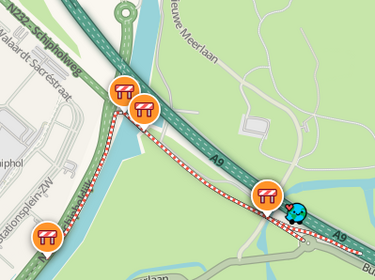
Real Time Closures (RTC) are used when a road or turn is temporary is closed. Placed closures are immediately active. From the moment a closure is active, routes are no longer provided over the closed segments. Active closures are indicated in the app and on the Live map with candy stripes (red-white stripes) on the closed segments.
A closed segment is treated as PB by Waze. This means that you will be brought closest to your destination as the crow flies. So keep that in mind when closing longer segments; where is the user directed?
In addition to closing one or more segments, specific turns ![]() can also be closed. For an explanation of this type of closure, see the Turn Closures page.
can also be closed. For an explanation of this type of closure, see the Turn Closures page.
Closures can be entered - when the Closures map layer is activated - by editors with Level 3 and higher and by members of the Closure team.
App closures

App users can indicate a road closure in the app when they encounter them during their ride. The notifications are immediately active as an hour-long RTC and automatically shared, via the closures bot with the editors in the Slack channel: .com/archives/C05N7S3PF1U #closures-bot.
The date on which an App closure is entered is used as the start date of the closure. App closures are almost always 1-way traffic closures.
To change the end date of an App closure: remove the App closure and add a new one.
Closure information
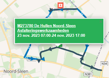
An important source of road closures is the Melvin website. Melvin is used by road authorities to report work and events.
Other sources are:
- The Bouwapp and apps from specific road construction companies / project developers.
- Andes, an accessibility portal is available for various cities, for example The Hague
- Municipality websites
- Local media
Closure requests
Requests for closures are welcome in the Slack closure channel. Wazers who want to report closures and do not have a Slack account can do so via the forum: Dutch forum closures.

Specify your closure request as follows:
- Level
- City and optional street name.
- Start date and time / End date and time
- Reason for closure / description
- A permalink of the segment to be closed
- Source of the closure information
Enter Closings
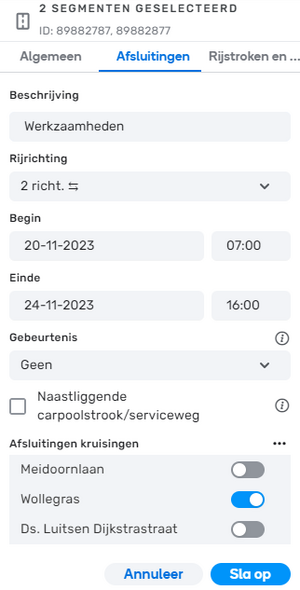
Select the segments for which you want to enter the closure and click on the Closure tab.
Now click on the Add a new closure button.
Then enter the following information:
- Description: If possible, provide a description of the work and the source. For example, "Asphalting work - Melvin 257413", "Work - Municipal site" or "Closure - own observation". If the Description field does not have enough space, add a Map Comment.
- Direction: A→B, B→A, 2 dir.⇆
- Start and End date and time of the closure.
- Event: None or one of the available Major Traffic Events.
- Adjacent carpool lane / service road: When a certain amount of traffic drives over a segment with an active closure, this closure can be lifted. This is checked every 10 minutes. When there is no more traffic, a lifted closure will return until the end time is reached. This feature can be turned off by checking Adjacent carpool lane / service road.
- Closed intersections: Indicate which intersections are closed to cross traffic.
And then click on the Save button.
 The closure is shown with black arrows indicating the closed directions. Here, both directions are closed. The closure of one direction is indicated with one black arrow in the closed direction.
Opmerkingen
- Afsluitingen van snelweg op- en afritten moeten, bij voorkeur via Wegstatus, handmatig geplaatst worden. Kortdurende op- en afritafsluitingen zoals bij snoei- en kapwerkzaamheden en het reinigen van kolken en putten worden niet verwerkt in Wegstatus.
- Afsluiten van een Verzorgingsplaats doen we niet om vreemde routes met een afgesloten Verzorgingsplaats als bestemming te voorkomen.
- Afsluitingen die vanuit de editor worden ingevoerd worden vastgelegd in de segment history. Bij de datum en de editor is dan zichtbaar "Road Closure added".
- Let op met relatief kortdurende afsluitingen: Sluit geen wegen af voor afsluitingen die naar verwachting korter duren dan het omrijden over de volledige alternatieve route. Denk bijvoorbeeld aan afsluitingen van de Houtribdijk, Afsluitdijk, Zeelandbrug, Westerscheldetunnel.
Closure status
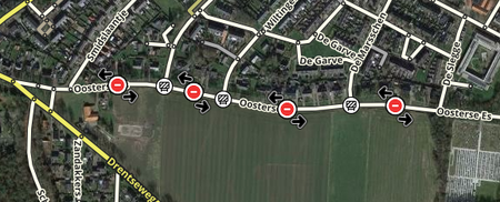
Afsluitingen worden in vier stadia in de WME vertoond:
- toekomstige afsluitingen (grijs bord)
- actieve closures (rood bord)
- opgeschorte afsluitingen (oranje bord)
- afgelopen afsluitingen (wit bord)
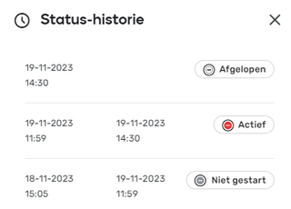

De Status historie kun je opvragen door op de statustag te klikken.
Reeds afgelopen afsluitingen blijven zeven dagen beschikbaar.
Een afsluiting wordt opgeschort wanneer het tijdstip van de sluiting is begonnen, maar er is nog steeds realtime verkeer op het segment.
Scripts
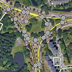
En verder
- CCP-partner Wegstatus verzamelt closure informatie van diverse Nederlandse organisaties. Deze informatie wordt gebruikt voor geplande en realtime closures in Waze.
- In sommige gebieden managen Veiligheids Regio's RTC's.
- Bij een afsluiting gemaakt op basis van partnergegevens wordt de provider in WME aangegeven.
- Zie ook UR's vanwege snelweg werkzaamheden
- Voor meer informatie over afsluitingen, zie de globale Real time closures pagina.
